Google is relaunching Street View, the Google Maps feature that allows users to explore an area through 360-degree panoramic street-level images, in India roughly six years after the South Asian nation rejected the feature over national security concerns.
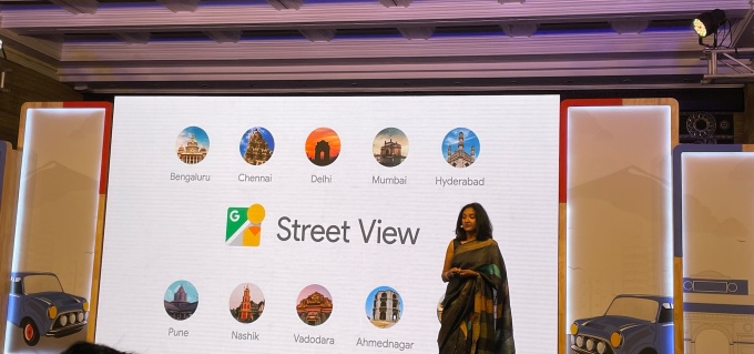
The company, which has been attempting to launch Street View in the country for over 10 years, said it has partnered with local giants Genesys and Tech Mahindra to relaunch the service, which is now live in 10 Indian cities. The company expects to roll out the feature to 50 Indian cities by the end of the year.
This is the first time that, Google executives said at a press briefing in New Delhi Wednesday, Google has partnered with third-party firms for Street View. Unveiled 15 years ago, Street View is live in over 100 countries and territories and has amassed over 220 billion Street View images, the company said earlier this year.
“Starting today, Street View will be available on Google Maps with fresh imagery intensity in India is covering 150,000 kilometers (93,205 miles) of roads that’s actually been ingested into Google Maps,” said Miriam Karthika Daniel, VP – Maps Experiences at Google, at the event. “So I’m really thrilled about how people will start using Street View and in India and see how we have suddenly everyday lives.”

Miriam Karthika Daniel, VP – Maps Experiences at Google, discussing the relaunch of Street View in India at an event in New Delhi. Image credits: Jagmeet Singh / TechCrunch
Karthika Daniel, who joined Google last year from Amazon, said the company is opening up access to Street View API to local developers. “This will enable them to integrate with mapping experiences and all of their products and services going forward,” she said.
India rejected Google’s plans to collect images for its Street View service in 2016 over security concerns of sensitive defence installations.
“We remain committed to collaborating with local organizations and the government as we work toward delivering even more useful features and information on Maps. We will continue to do this responsibly, enabling accurate, authentic, and trustworthy information. We look forward to extending our technology and expertise to the local ecosystem,” said Miriam.
On the sidelines of Street View launch, Google also announced a number of other features it is bringing to Google Maps. One such feature will show speed limits data shared by the traffic authorities on the maps app. The company said the feature, to be rolled out first in Bengaluru, is aimed at promoting safe driving.
“We are proud to partner with Google to use technology to help reduce traffic congestion and improve road safety for the people of Bengaluru. We are the first Indian city to have started a pilot with Google to optimize the traffic light configuration in Bengaluru to reduce signal wait time for commuters. As per the data provided by Google, the revised plan by Google resulted in an average 20% wait time reduction per driver going through the pilot intersection during the day,” said Ravikanthe Gowda, Joint Commissioner of Police (Traffic) in Bengaluru, in a statement.
Google said it has also partnered with traffic authorities and aggregators to help people across eight Indian cities — Delhi, Hyderabad, Chandigarh, Ahmedabad, Kolkata, Gurgaon, Bangalore, and Agra — make improved travel decisions and avoid congestion zones with information on road closures and incidents.
This is a developing story. More to follow…

